
Your source for Mountain Biking in the Triangle
Raleigh-Durham-Chapel Hill
|
|
Your source for Mountain Biking in the Triangle Raleigh-Durham-Chapel Hill |
||||||||
| Category | Average Rating |
| Overall : |  3.6 / 5.0 based on 30 votes 3.6 / 5.0 based on 30 votes |
| Technical : | 3.3 / 5.0 based on 30 votes |
| Climbing : | 3.3 / 5.0 based on 30 votes |
| Freeride : |  2.1 / 5.0 based on 30 votes 2.1 / 5.0 based on 30 votes |
| Scenery/Wildlife : |  2.8 / 5.0 based on 30 votes 2.8 / 5.0 based on 30 votes |
| Flow : |  2.6 / 5.0 based on 19 votes 2.6 / 5.0 based on 19 votes |
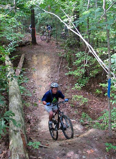
Description: 5 tight and twisty miles tucked in behind Garner Recreation Park. Spend some time exploring, it's worth it! A few technical areas and a big whoop de doo pit. Ride it backwards and forwards for a longer ride.
News! 1/13/2005
Just and update on the Garner trails, the new stuff is
finished. Two new loops adding almost two miles to the
trails. All the new stuff runs off to the right of the
bridge at the creek down the old trail that used to
deadend. One trail follows the creek and goes up behind
the school playground. The other loop goes across the
creek and ends back where you started at the blue trail.
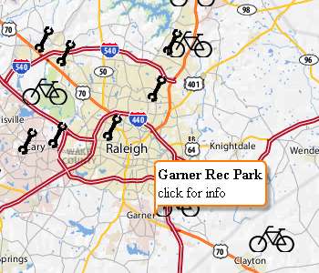
Location: Garner
Miles: 5
Skill Level: Intermediate
Park Hours and Fees
No fee, hours from dawn to dusk.
 Directions
From Raleigh take Highway 70 east to Garner, exit at Vandora Springs Road
exit, turn left, go across the railroad tracks turn
right, follow this about two miles to you see the old
train depot on the right, just past the depot you will
see Garner Recreation Park entrance on the left, turn in
there and go all the way to the bottom of the parking
lot. The trail head will be on the right over the bridge.
 Driving Directions via Google
Rules of the Trail
1) Trails closed when wet.
2) Trails close 1/2 hour before park closes.
3) Helmets required.
4) Don't litter.

Rules, guidelines, and definitions for our TriangleMTB.com trail reviews
|
If I went to this trail when I first started riding mountain bikes I probably would have quit! Haha. But now that I know how to ride over roots and love a good challenge these trails are pretty fun for a quick hard ride. There is not much marked so you just have to ride it a few times to figure out where you are going. I'm not sure why this isn't listed on the mail tail page anymore but it's a fun ride. | ||||||||||||||||||
|
Rode this trail for the first time today when trying to find trails that were open after the rain. This trail is part of the park, so if the park is open, the trail is most likely open. The entrance to the trail is toward the back of the parking lot and there is no one there monitoring it. Trail is pretty "rooty" is some parts, and pretty tight is some spots. I wouldn't recommend as a beginner trail, but definitely fun as a good intermediate ride. Some parts had not been traveled on in a while as the path was covered in pine straw and leaves, which made some of the slopes harder to go up, plus they were still a little wet. Trail is not marked very well, and there are several points where it forks and you have no idea where you're going. I actually think we were on private property at some points. Overall, seems like a really fun trail with some slopes, bridges, creeks, whoop-de-doos, and more. Will definitely try again when it hasn't rained recently. |
||||||||||||||||||
|
Flow is difficult because trail builders took advantage of every whoop, knob, hill, and root ball in the general vicinity of the path. Can be fun for sure but overdone at the expense of flow IMO. It'd also be nice to have a clue where you are and where you're going. I grew weary of pulling out my phone to see where I'd been to try to guess where to go. At one point I just bailed for a ball field I could see at the edge of the woods. The trail has potential tho, with some more use and signage... | ||||||||||||||||||
|
This trail has potential but the lack of upkeep and overall simplicity takes out the fun of the trail. this trail is no where near 5 miles and is made up of 3 small trails a blue, red and green trail which totaling maybe 2-2.5 miles. now that is the marked trails if one goes into the no trespassing marked sections it would probably be longer, but i was unwilling to test this hypothesis. overall it seems to be more of a hiking trail where one would take their dog for a walk. the over abundance of high roots makes climbing difficult and slows down the overall pace there are some fast turns and a couple fun drops, but not enough to make Garner my ideal place to ride. | ||||||||||||||||||
|
No detailed review given. | ||||||||||||||||||
|
The harder stuff lies beyond the park boundaries, I assume these are either illegal trail systems or just plan hard to find. You can get lost going in circles here, many connectors and forks at every turn. Spent more time deciding where to go and how to get back. Once you get a idea of the area though there is some good potential for fun. Some whoops, climbs, creek crossings, flows at back end well. I still don't think I ridden it all yet... Worth it if your in the area, but would be nice if it was more organized and maintained. Lots of dog walkers near beginning of trail system. | ||||||||||||||||||
|
I think a bad sign of a not so good trail is it being covered with leaves or looking like nobody rides it. I went out there yesterday from Raleigh and probably won't return. Although the trees are clearly marked with paint the trail isn't very organized. If you like a ton of tight lines and no flow go here. Not to mention I ran over dog poop...Not that fun of a ride for me | ||||||||||||||||||
|
As mentioned by others, had a little difficulty finding the park as is not prominently marked. Trailhead is obvious once you're in the right parking lot.
The first section of trail (from the trailhead bridge to the "other bridge") seems to be a complete cluster of connector trails with a fork in the road about every 50 feet. Virtually every tree on every connector seems to have paint on it. Once you get to the trails beyond the "other bridge" things improve a little but trail markings dissapear altogether. As far as I can tell, the only good plan here is to give yourself a couple of hours to ride around in circles until you have a general sense of the place. Maybe after a half dozen days like this you could start riding fast with a particular plan. There are countless ride around sneaks at even the mildest obstacles, which might be nice for accomodating varrying skills, but they add to the confusion making you think you're at yet another fork in the road. This trail can be fun to ride and has a lot of potential. I'm surprised that with an organised biking community it's not marked better. |
||||||||||||||||||
|
Where to I start? First off with the negative: - Very poor markings for which trail you are on. They have Red, Blue, and Green. It's just paint smeared on some trees. I planned on doing all three but ended up just riding till I had enough. There were plenty of times there was a fork coming up and I had no clue which way to go. If you get lost, good luck finding which way is which. - Quite a few things like dips, quick turns, big logs, and low tree limbs have a way of coming up with no real idea they are there or coming up until you've hit them. Pay attention! - I read somewhere someone said that they felt all alone out there. Like it was in the middle of no where and they were at peace with nature... Totally the opposite! Haha, every time I thought I was almost away from civilization, I saw a baseball field, the road, a townhouse, a shelter, power unit, etc. Positives: - Nice slopes, quick turns, tight lanes. - Plenty of ride arounds for those not confident with their riding skill. - There is another trail that starts inside this one. You'll see a sign that says " Town Trail ends here. Town is not responsible or liable for damage" ETC. Or maybe it's still apart of it but town doesn't keep it up? I don't know but that was fun =) All and all I will return to this trail and ride it over and over for the next week or two. I say everyone should take the time to ride this trail. P.S - Be careful on the steepest climb prob close to middle of the overall trail. There is a steep and root filled downhill after the crest. Either keep going and don't stop or walk down it. DO NOT attempt to walk down a little of it and then start riding. |
||||||||||||||||||
|
Decent trail. Some pretty steep uphills if you are a beginner. Dont know if it is worth the drive from Raleigh. Just my opinion. | ||||||||||||||||||


